‘Til Death Do Us Part
Burial identification in collaboration with LJ Moore

In 2008, the skeletal remains of two individuals were recovered from the former site of San Francsico’s Odd Fellows Cemetery, a 19th century burial ground that was removed to Colma in the early 1930s. Various artifacts were recovered with the burials, including a wedding band engraved with two sets of initials. The remains went unidentified and were later reburied. A decade later, the authors analyzed and crossed-referenced surviving cemetery records with a variety of other historical materials to map a large portion of the cemetery and, ultimately, identify both individuals.
This research was presented to the Society for California Archeology, the San Francisco Historical Society, and the Western Neighborhoods Project.
View the slide deck.
Mapping Yerba Buena Cemetery

From 1850 until 1870, a pioneer burial ground known as Yerba Buena Cemetery existed in what is now the heart of San Francisco. At it’s peak, the cemetery held the remains of an estimated 7,000 people. No trace of the cemetery exists today—above ground, at least. Although supposedly cleared of bodies by the city in 1870, fragments of the cemetery—including in situ burials and headstones—have turned up in nearly every decade since.
Despite its central place in San Francisco, relatively little is known about the physical and social fabric of the cemetery. I am working to change that by creating a three-dimensional model of the burial ground based on newspaper articles, local histories, photographs, and surviving cemetery records, to aid future archaeological recoveries.
During the course of this project, I discovered that, contrary to the prevailing understanding of Bay Area genealogists, the Yerba Buena Cemetery records were not lost to time but are in fact alive and well, tucked away within the mortuary records of Nathaniel Gray. In 1881, Nathaniel Gray explained to the San Francisco Bulletin how he obtained these records:
… I have the records of Yerba Buena Cemetery, the city never having taken any action toward procuring them from me. By the advice of Mayor Tischmaker [sic] I bought the records of interment in Yerba Buena from 1854 to 1857 of John T. Wallace I was City Sexton when Yerba Buena was first used, March, 1850, up to June 1854 and had those records.
If you are interested in a copy of the map, please contact me.
THE FORGOTTEN CHILD OF CAROLTON
Burial identification in collaboration with Jelmer Eerkens

When the U.S. Army Corps of Engineers dammed the American River at Folsom, California in the mid-1950s, numerous small communities were permanently flooded out. In preparation for the rising waters, the Army Corps moved eight Gold Rush-era cemeteries that were located in flood zone.
However, not every burial was recovered. During dry conditions in the 1970s or 1980s, a zinc-encased coffin containing the bones of a young child was discovered at Dotons Point. Research indicates the child had been buried on what had once been the outskirts of the town of Carrolton, a small mining camp that flourished briefly in the 1850s and 1860s.
For this project, I am teaming up with a UC Davis archaeologist Jelmer Eerkens to shed new light on the identity of this child.
A New Look at Old CIty Cemetery
In collaboration with John Martini

From 1870 until the early 20th century, San Francisco’s Lincoln Park Golf Course was “City Cemetery”, a windblown assemblage of fraternal and ethnic burial plots as well as the city's Potter's Field. In 1906, the cemetery’s records were destroyed by fire, and in 1909 the burial ground was closed down and converted into a park. All the cemetery’s remains were relocated—or so people thought.
In the early 1990s, the remains of at least 800 people were discovered on former cemetery property. Who exactly were these people? Why had they been left behind? And would it be possible to map the old cemetery to better contextualize—or possibly even identify—future burials that might turn up?
To answer these and other questions, I teamed up Bay Area historian John Martini. Over the course of a year, we cross-referenced hundreds of historical sources—including newspaper articles, fragmentary city records, federal survey maps, and photographs—to create a detailed map that identifies the location and extent of most of the cemetery's burial plots.
In the process, we learned that when city officials “converted” the cemetery to a park in 1909, they did so by simply removing grave markers; burials that weren’t privately removed were simply left in place. And no attempt was ever made to remove the indigent dead.
Today, we estimate that the remains of at least 11,043 individuals still rest beneath the park’s manicured fairways.
If you are interested in a copy of the map, please contact me.
This research was presented to the San Francisco Public Library, the Society for California Archeology, and the Western Neighborhoods Project (February 2019).
View the slide deck.
UnMasking Odd Fellows Cemetery
Forensic cartography

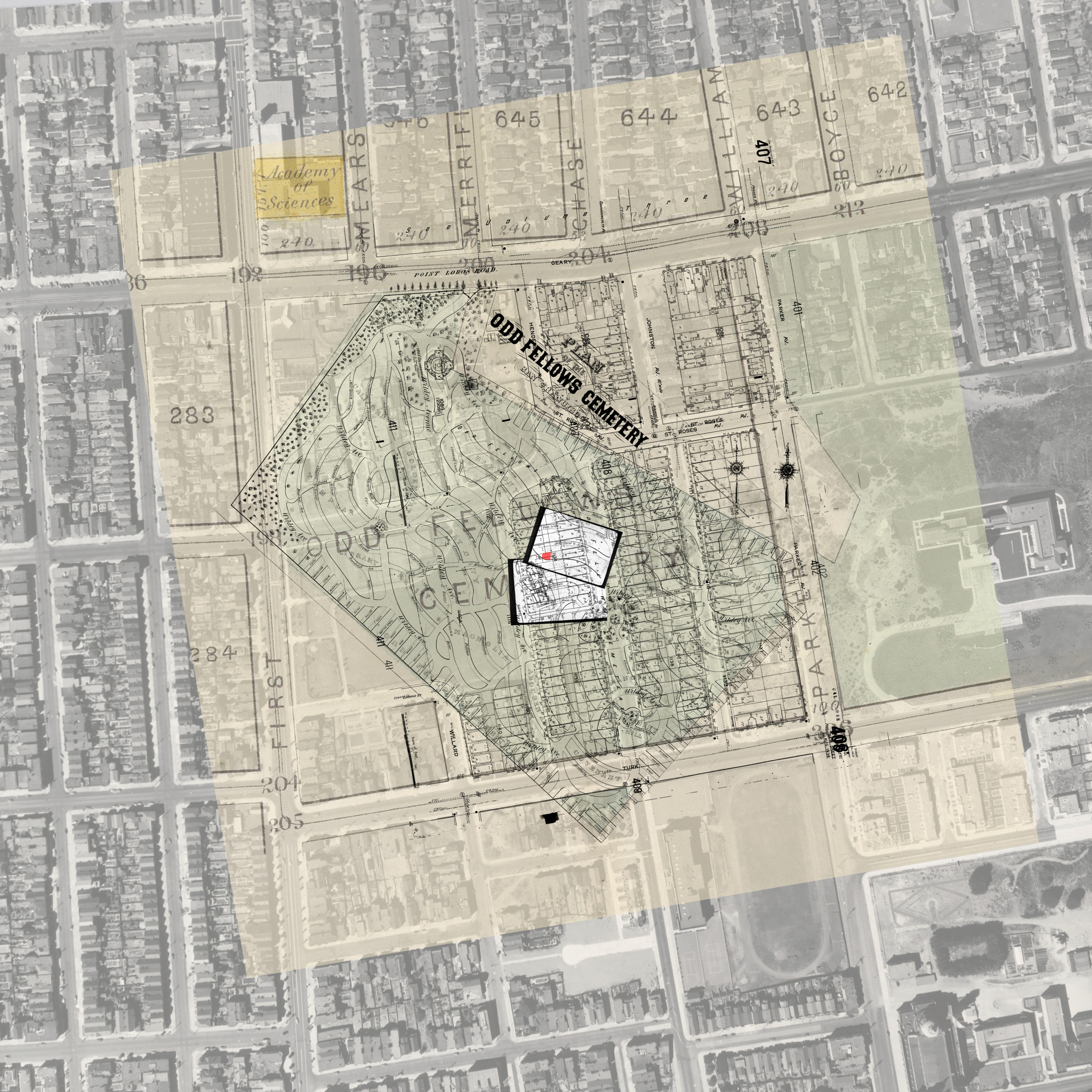
No complete map of San Francisco's old Odd Fellows Cemetery is known to exist. The cemetery existed from 1865 until the 1930s, when the burial ground was removed to Colma, California. Not all the dead made the move, however, and human remains have periodically been recovered during ground-disturbing construction projects.
To assist these recoveries, I cross referenced newspaper articles, photographs, and surviving cemetery records to create a GIS map of the cemetery. The cemetery is approximately 75 percent mapped—the best that can be accomplished given the currently-available level of information—and a copy of this map is now on file at the San Francisco Planning Department.
This exercise in reconstructive cartography was an outgrowth of my work on the Edith Howard Cook investigation (see below), which built out a small portion of the former cemetery to help identify the remains of a young girl found during a backyard landscaping project in 2016.
If you are interested in a copy of the map, please contact me.
The Girl in the Metal Casket
Burial identification in collaboration with Elissa Davey, Bob Phillips, Dave Frederick, Jelmer Eerkens, and Ed Green

In the 1930s, San Francisco evicted its dead. Tens of thousands of human remains once interred in large cemeteries across the city were exhumed and sent to new burial grounds beyond the city limits. Not all the dead made the move, however, and in May 2016, the incredibly well-preserved remains of toddler were unearthed during a backyard landscaping project at a property located on what had once been Odd Fellows Cemetery property.
For this project, I constructed a map overlay that revealed which family plot the girl had been buried in—a critical step in her eventual identification as Edith Howard Cook, laid to rest on October 13, 1876.
The Missing Grand Master
Historical research

When the Odd Fellows Cemetery in San Francisco was vacated in the 1930s, the remains of some individuals were reinterred in private burial plots, but the majority were moved to a general burial plot a few miles south of the city. For years, one interested party wondered what became of the remains of Samuel H. Parker, the first grand master of the California Odd Fellows. In the 1860s, Parker was buried beneath a 30-foot granite obelisk in the most prominent part of the cemetery. His monument was even repaired after shattering in the 1906 earthquake. Despite all this, there seemed to be no record of what became of his remains after Odd Fellows Cemetery was closed down. This prompted some speculation from one interested party that he might still be buried on former cemetery property.
Through careful records research, however, I was able to show that Parker, against all odds, was actually sent to the mass grave in Colma—a surprising twist of fate for a man such prominence.